Show a POI on the Map
In this guide we will
- listen to the CLICK event on the map
- reverse geocode the click event in order to display the address under the POI
- setup a POI with the address to be displayed on the maps
- send and show the POI on the Map
Follow common setup steps
If not done already, follow common Introduction page.
Listen to the CLICK event
Click on the map on the desired location.
You will received a CLICK event message
Payload example of a CLICK event message
{
    "pos": {
        "lonLat": [
            -0.56168682235152,
            47.4624835894391
        ]
    },
    "hitEntities": [],
    "hitFeatures": []
}
Reverse geocode the coordinates
Build a SitePoint
Build a SitePoint with the position received.
SitePoint example
{
    "id": "0DD2BD59-B7FF-46DA-AA21-0F38CAE07C89",
    "longitude": -0.56168682235152,
    "latitude": 47.4624835894391
}
Send a ReverseGeocode message
Build a Reverse geocode message and send it with the SDK SendEvent function.
Payload example of a reverse geocode message
[
    {
        "id": "0DD2BD59-B7FF-46DA-AA21-0F38CAE07C89",
        "longitude": -0.56168682235152,
        "latitude": 47.4624835894391
    }
]
Listen to the Job progress message
The SDK will send a Job progress event message.
Payload example of a reverse geocode job progress message
{
    "api": "CARTO",
    "jobId": "6E8F86EC-9367-4B3E-A1F2-DC52678BF04A",
    "action": "REVERSE_GEOCODE",
    "progress": "COMPLETE",
    "lastMessage": true,
    "statusCode": 200,
    "message": "Reverse geocode : 1\/1",
    "jobData": [
        {
            "id": "0DD2BD59-B7FF-46DA-AA21-0F38CAE07C89",
            "longitude": -0.56168682235152,
            "latitude": 47.4624835894391,
            "road": {
                "id": "14734175",
                "arcab": 0,
                "arcba": 27540190,
                "roadtype": 0,
                "name": "Rue Fulton",
                "distance": 90,
                "speedcat": 1,
                "roadlevel": 5,
                "geometries": [
                    [
                        -0.562081,
                        47.462442
                    ],
                    [
                        -0.560987,
                        47.462767
                    ]
                ]
            },
            "position": {
                "arc_index": 25995277,
                "percentage": 34,
                "nodeid": 12343460,
                "longitude": -0.561707,
                "latitude": 47.462553,
                "distfromroad": 8,
                "sideofroad": 1
            },
            "address": {
                "number": 10,
                "streetname": "Rue Fulton",
                "suburb": "",
                "zipcode": "49000",
                "cityname": "Angers",
                "region": "Maine-et-Loire",
                "subcountry": "Pays de la Loire",
                "country": "FRA"
            }
        }
    ]
}
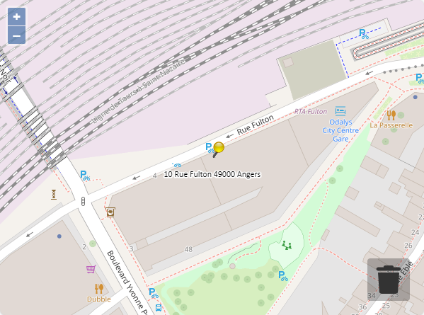
Display a POI on the map
Build a WebviewPOI
Build a WebviewPOI with a label coming from the reverse geocode.
Example of a POI with a label coming from Reverse geocode
{
    "id": "0DD2BD59-B7FF-46DA-AA21-0F38CAE07C89",
    "pos": {
        "lonLat": [
            -0.56168682235152,
            47.4624835894391
        ]
    },
    "icon": "pin_yellow_syd.png",
    "displayOptions": {
        "width": 18,
        "height": 24,
        "anchor": [
            0,
            1
        ]
    },
    "label": "10 Rue Fulton 49000 Angers"
}
Send a Entitie message
Build a Entities message and send it with the SDK SendEvent function.
Payload example of a Entites message with a POI
{
    "pois": [
        {
            "id": "0DD2BD59-B7FF-46DA-AA21-0F38CAE07C89",
            "pos": {
                "lonLat": [
                    -0.56168682235152,
                    47.4624835894391
                ]
            },
            "icon": "pin_yellow_syd.png",
            "displayOptions": {
                "width": 18,
                "height": 24,
                "anchor": [
                    0,
                    1
                ]
            },
            "label": "10 Rue Fulton 49000 Angers"
        }
    ]
}
Map display